Challenging climbs, switchbacks and descents over steep, rocky slopes; solitude and seclusion deep within Southern Appalachian wilderness; precarious stream fords, and of course, the long distance itself. Since its meager beginnings in the early 70s when the first fire axe dug into the rocky hillsides of Alabama’s Talladega National Forest at Coleman Lake, the 335-mile Pinhoti Trail has become known as a premier long-distance hike in the Southeast.
The Pinhoti Trail stretches from Flag Mountain in Weogufka, Alabama (which is recognized as the last mountain in the southern Appalachians) to the Benton MacKaye Trail in Georgia, where it connects to the 2,181-mile Appalachian Trail (AT). Its 171-miles of trail in Alabama are some of the most rugged and wild hiking you can find in the Southeast. It’s the perfect training ground for test driving your gear and getting in shape both mentally and physically for tackling the AT and other long-distance hikes. The challenging hiking continues with even more rugged climbs and descents after the trail crosses into Georgia.
Even though the route has a lot of hurdles to conquer, the trail never veers too far away from civilization. If you find yourself in a situation where you need to call it quits, you can usually bail without too much trouble.
The trail has 13 sections in Alabama and 31 in Georgia. Within each of these sections, there are miles and miles of trail that will put your stamina and determination to the test. Here, a breakdown of the 10 toughest sections of the Pinhoti, where they sit along the trail, and what you can expect from them.
A post shared by Carl Applequist (@spaztech) on Nov 13, 2019 at 2:46pm PST
The sections listed here are listed in northbound order. The mile markers provided are how far into the section you will find the challenge. Please visit the Pinhoti Trail Alliance and the Georgia Pinhoti Trail Association websites for detailed descriptions of the trail in its entirety.
Hope your knees are ready for a bit of downhill. As you come down off the 1,585-foot Horn Mountain ridge, you will be faced with a series of 24 steep switchbacks that you will need to navigate to get back to more even ground.
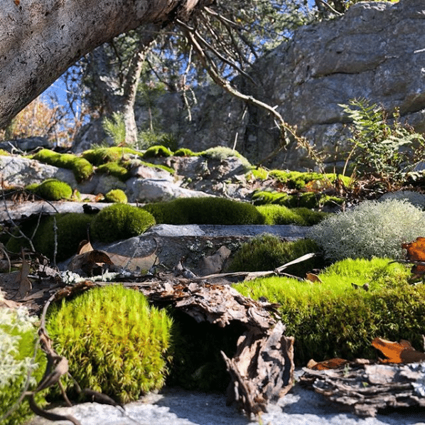
You may need to reconsider how many miles you can put in on a single day when you hike through the Rock Garden. It’s one of the toughest sections of the entire hike second only to Stairway to Heaven (see below) and many hikers dread the little “stroll” through the garden. This 1.9-mile walk heads up and over 14 rock fields that consist of medium-size loose rocks that make the going slow—this is a turned ankle waiting to happen. The Pinhoti Trail Alliance says that “with the proper attitude adjustment…plan on at least two hard hours .”
When asked, nine out of 10 Pinhoti hikers will tell you the Stairway to Heaven is the most challenging part of the entire hike. The section begins at 1,575 feet and is easy enough with relatively flat terrain but don’t get too comfortable. This is soon followed by a 0.5-mile climb through a huge rock garden by way of what is described as a series of “tricky little uphill switchbacks”—at times you may find yourself climbing hand-over-hand.
As you near the top of the climb at 2,050 feet, things level out, but not by much. This area is commonly known as the Pearly Gates which ends at the top of the 2,135-foot ridge, Heaven (aka Rocky Top).
Another steep descent comes in Section 7 at mile 2.6 as the Pinhoti Trail crosses the Bald Rock Trail. It’s a solid 2.6-mile, 1,051-foot descent down to the bottom of Blue Mountain just outside of Cheaha State Park and the trail’s crossing of Cheaha Road. To make the steep down hike more interesting, there is a rock scramble smack dab in the middle of the descent.
Also located in Section 7 is the crossing of Hillibee Creek. Under normal circumstances, the creek itself is a beautiful, tranquil stream sitting at around 15-feet wide and about a foot deep. When there has been a significant rainfall, however, things can get sketchy quickly. The creek’s steep banks fill fast and water rapidly becomes waist deep and swift. Extreme caution is required to cross during these times and it is recommended that you off-trail it and head downstream to find a better, safer route across.
Found in the Duggar Mountain Wilderness, a challenging section unto itself, the 1.8-mile ascent at Mile 6.4 is another muscle-quivering, rugged climb of 1,040-feet.
This section provides incredible views, especially from the top of Davis Mountain, but in order to get to them you will need to accomplish a series of steep, rocky climbs of 880-, 780-, 850-, 920-, 1,380-, 1,156-, and 1,871-feet all within a stretch of 1.6-miles.
The 1,130-foot hike up Flag Pole Mountain is the last stiff climb of the Alabama Pinhoti and comes just as you near the state line into Georgia.
Also known as The Snake, this section, which offers stunning views and wildflowers, is one of the most beautiful along the Pinhoti Trail according to many. This part of the trail is also home to four mountains that you need to get up and over, rock gardens, and very steep grades both up and down.
Besides being extremely difficult due to steep scrambles up and down rock outcroppings and loose rock, the last 22-miles of the trail is one of the remotest sections of the Pinhoti. Not only do you have to be ready for all the natural landscape throws at you, but you also need to have expertise navigating in the backcountry and be prepared for emergencies. It’s essential to pack along plenty of water.
The Pinhoti Trail is not for the faint of heart and there is no doubt it will challenge you. If you head in prepared and knowing what you are up against you are bound to come out stronger at the end, or at the very least having learned something. Get ready to suck wind, manage burning quads, navigate remote backcountry, and have an awesome time.
Written by Joe Cuhaj for Matcha in partnership with Catoma.
Featured image provided by ktrussell15